Tides Near Me
- 4.7
- Rating
- 1.00M
- Installs
- Free
- Price

 Analysis by App-foxy
I use weather apps for quick decisions, but tide information needs a different kind of attention. A general forecast can tell me whether to expect rain or wind; it does not necessarily help me decide when a beach will be accessible, whether a shallow launch point is practical, or how much water may be moving through a local inlet. That is where Tides Near Me makes sense. It is a focused weather app from Shelter Island Mapping Company, LLC, built around nearby tide charts and current predictions rather than trying to become an all-purpose forecast service.
After spending time with it, my impression is that its value comes from concentration. The app is not trying to bury tide information beneath radar maps, lifestyle cards, breaking alerts, or a long list of unrelated weather tools. It gives people who live near the coast, visit beaches, fish from shore, kayak, paddleboard, or simply plan around changing water levels a more direct way to check the day. If tides are part of your routine, this is much more useful than a standard weather app alone.
It is free to install and suitable for Everyone, which makes trying it low-risk. The app has been available since Mar 11, 2013, and its long presence is reflected in its reach: it has passed 1M+ installs, with a 4.7 average from around 91K ratings and roughly 10K written reviews. Those figures do not replace my own judgement, but they do suggest that the basic idea has remained useful to a substantial audience.
You May Also Like

 Blood Strike: 2.5 Anniversary
Blood Strike’s Loadouts Turn Every Drop Into a Tactical Gamble
A close look at Blood Strike’s custom loadouts: how fast access to signature weapons reshapes its battle royale rhythm, rewards preparation, and narrows the gap between fights.

 Pandora - Music & Podcasts
Pandora’s Music Is Easy to Start, but Harder to Recover
Pandora’s strength is its low-effort path from a seed to a station. Its weak spot is how much confidence it asks you to place in connection, setup, and quiet recovery.

 8 Ball Pool
 Is Built on Rivalries, Rematches, and Routine
A close look at the rivalries, rematches, shared routines, and unanswered safety questions that turn a quick pool match into a persistent mobile community.

 Samsung Music
’s Quiet Strength Is Playing What You Already Own
Its reach comes less from spectacle than from dependable access to a personal library. That simplicity is both the app’s strongest retention engine and its ceiling.

 AccuWeather: Weather Radar
AccuWeather Review: A Quick, Clear Forecast for Everyday Decisions
For everyday plans, the best forecast is the one you can understand quickly. AccuWeather makes rain timing, radar, and local conditions easy to act on, with a few trade-offs.

 Hill Climb Racing
Why Hill Climb Racing Still Turns Crashes Into One More Run
A tiny car, a bumpy hill and one more upgrade: Hill Climb Racing keeps resurfacing because its simple chaos makes every near-miss feel personal.
More From Our News Desk



Why a dedicated tide app earns a place on my phone
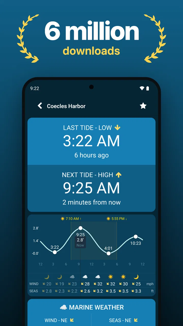
The first thing I appreciate is that the app treats tides as something to consult repeatedly, not as a small detail hidden inside a broader forecast. When I open it before heading out, I am looking for a sequence of high and low water times, an indication of the changing level, and current information close to the place I care about. A dedicated layout makes that check faster than moving through several screens in a general weather service.
That focus is especially helpful for activities with a narrow timing window. A beach walk may be possible at one part of the day and awkward later. A boat ramp can be convenient at one tide and frustrating at another. Someone collecting shellfish, photographing a shoreline, or checking a familiar fishing spot may care more about water movement than the temperature. The app does not need to predict everything about the day to be useful in those situations.
I also like the distinction between tide charts and current predictions. They answer related but different questions. A chart helps me understand the expected rise and fall of the water. Current information is more relevant when movement matters, such as near channels, bridges, inlets, or narrow passages. Treating both as part of the same routine is more sensible than assuming a high-tide time tells me everything I need to know about conditions on the water.
One practical habit is to check the app twice: once while planning and again shortly before leaving. The first check helps me choose a suitable time. The second lets me confirm that I am still looking at the intended location and the relevant part of the day. That small pause prevents a common mistake with location-based tools: relying on a remembered place or an old screenshot instead of checking the current selection.
What the nearby focus does well
The nearby approach reduces friction for casual users. I do not have to begin by understanding every station name along a coastline. If I am traveling, I can use the local context as a starting point, then make sure the selected station actually represents the stretch of coast, harbor, river mouth, or launch area I plan to visit. That second step matters because “nearby” is convenient, but the closest station is not automatically the most representative one.
This is one of the app’s less obvious strengths: it encourages a more realistic planning question. Instead of asking only, “What is the tide today?” I can ask, “Which observation point best matches where I will be?” That is a better workflow for unfamiliar coastlines, where a nearby station may sit on the other side of a headland or in a protected harbor with different local behavior.
The same point is also a limitation. Anyone who expects a tide app to make a location choice perfectly on their behalf may need to spend a moment checking the station context. I would not treat the first nearby result as unquestionable, especially for safety-sensitive outings. The app helps me find and read the information; it does not remove the responsibility to understand the local geography.
Widgets and Wear OS support in daily use
Support for widgets is more important here than it might sound. Tides are often checked in a hurry: before leaving home, while packing equipment, or when deciding whether to extend a walk. A widget can make that glance more immediate than opening the full app every time. I see the feature as a convenience for routine checks rather than a replacement for opening the app when I need more context.
Wear OS support serves a similar purpose. If I am already wearing a compatible watch, a quick glance can be useful when my phone is in a bag or pocket. That is particularly practical near water, where handling a phone may be inconvenient. Still, I would use the watch view as a prompt, not as the only source for a serious outing. A small display is good for checking the next event or general timing, but less suitable for carefully comparing stations or interpreting a full day.
There is a trade-off with glanceable information. The easier it is to see a tide time, the easier it is to forget the surrounding conditions. I would still check the complete chart before kayaking, boating, or planning a route that depends on clearance. The widget and watch support improve access, but they should encourage a fuller check rather than replace it.
Trust, controls, and moments that deserve care
When I review an app that uses nearby information, I pay attention to the choices visible to the user. The practical trust question is not simply whether the app is popular. It is whether I can understand what I am doing when I select a location, whether I can avoid unnecessary steps, and whether the app remains useful when I prefer to make choices manually. With a tide tool, that matters because location is central to the experience.
I prefer to treat location as a deliberate decision. If I am at home planning a trip, I may want to look up the destination rather than use my current position. If I am already at the coast, nearby results may be the fastest route. These are different situations, and a good workflow gives me room to choose between them instead of assuming that the phone’s current location is always the right reference point.
That is also where I stay cautious. A location-based result can feel authoritative simply because it is close to me. I do not interpret proximity as proof that the station is ideal for my exact beach or launch site. Before relying on a prediction, I compare the selected place with the actual shoreline and consider whether the area has local features that could make conditions different.
For privacy-minded users, my advice is straightforward: use the least complicated location workflow that still gives you the station you need, and review the choices presented by your device when installing or using the app. I do not infer hidden data practices from the app’s category or popularity, and I would not make a privacy promise that is not visibly supported by the product’s own controls and notices. The responsible approach is to pay attention to the permission and account choices shown on your device, rather than assuming every location tool handles information identically.
The app’s free entry point is another positive for user agency. I can test whether its station coverage and presentation suit my coastline without committing money first. There are in-app purchases ranging from $1.99 to $29.99 per item, so I would look carefully at the purchase screen before confirming anything. The important distinction is that “free to install” does not mean every optional part of the experience is necessarily included at no cost.
I also prefer to make purchase decisions after using the basic workflow for a few days. That gives me time to find out whether the nearby station is the one I actually need, whether the chart is readable in my routine, and whether widgets or watch access change how often I use it. Paying for convenience only makes sense if the app has become part of my planning habits.
A realistic morning with the app
Imagine I am planning a Saturday paddle. On Friday evening, I open the app and choose the coastal location that matches the launch area rather than automatically accepting the first nearby result. I look at the tide sequence and current predictions, then compare the timing with the length of the trip I have in mind. If the route crosses a narrow passage, I pay more attention to current movement than to the high-tide label alone.
On Saturday morning, I check the widget or watch for a quick reminder, then open the full app before leaving. If the conditions no longer fit the plan, I change the departure time or choose a simpler route. The app does not make that decision for me, and that is appropriate. It gives me a focused piece of information so I can combine it with my own knowledge of the water, the forecast, equipment, and experience level.
For a less demanding example, I might be taking children to a tidal beach. I can use the chart to avoid arriving when the accessible sand is disappearing, while still checking the general weather separately. That division of labor is important: this app can be the tide specialist in my phone, while a broader forecast app handles rain, temperature, wind, and storm alerts.
Where it is stronger than ordinary weather alternatives
General weather apps are usually better when I want one screen covering temperature, precipitation, wind, radar, and alerts. They are convenient for everyday forecasting, but tide information may be secondary or presented with less detail. Tides Near Me is the better choice when the water level itself is the main planning variable and I want to reach that information quickly.
It is also more approachable than relying on a harbor website every time. Official or local sources can be valuable, particularly for ports, regulations, warnings, and specialized marine information. However, switching between web pages can be slow, and the presentation may not be designed for a quick mobile check. I see this app as a practical first stop, not a universal replacement for local authorities or specialist navigation tools.
Dedicated boating and navigation apps may be more suitable for experienced users who need route planning, charts, hazards, weather overlays, or other marine instruments in one place. They can offer a broader operational picture. The trade-off is complexity. If I only need tide timing and current predictions near me, a larger navigation suite may feel excessive. If I am making a serious passage, the narrower app should not be my only reference.
Who should use it, and who should skip it
I would recommend it to coastal residents, beach visitors, anglers, paddlers, photographers, campers near tidal areas, and anyone whose plans change with the shoreline. It is particularly appealing if you check the same places often and want a quick routine through a widget or Wear OS device. The free installation also makes it easy to test before deciding whether optional purchases add enough value.
I would be less enthusiastic for someone who lives far inland and rarely visits tidal water. In that case, the app may become a specialized tool opened only a few times a year, while a regular weather service may cover more useful daily needs. I would also steer professional mariners or users planning demanding trips toward a broader marine information setup, with local and official sources included in the decision.
People who want a complete forecast in one place should not mistake this for a replacement for their usual weather app. Its strength is the tide-focused layer. I would keep another source for wind, storms, visibility, and general conditions, then use this app to answer the water-level questions that broader services may handle less directly.
Small habits that make the information more useful
Before an unfamiliar trip, compare the selected nearby station with the actual destination instead of assuming the closest result is automatically correct.
Use the widget or watch view for reminders, but open the full chart when timing affects a route, launch, crossing, or return journey.
Separate tide information from general safety planning. A favorable tide does not by itself describe wind, waves, visibility, weather, or local hazards.
Check the app again before leaving if your plan depends on a narrow window, rather than relying on a note made the previous day.
Try the free experience first and inspect any optional purchase screen carefully before paying for extras.
These habits also clarify what the app can and cannot do. It can make tide and current information easier to consult, but it cannot turn an uncertain coastal plan into a guaranteed one. I value that distinction because the most dangerous mistake with a focused tool is allowing one accurate-looking detail to stand in for a complete assessment.
My cautious verdict
After using it as a dedicated tide reference, I think Tides Near Me is a strong fit for people who repeatedly plan around coastal water. Its clear purpose, nearby focus, widgets, and Wear OS support make it convenient without forcing me into a large navigation system. The app’s 4.7 average and broad adoption are consistent with that practical appeal, although I still recommend judging it by the station coverage and workflow where you live.
My reservations are mostly about interpretation and scope rather than the central idea. I would verify that the chosen location represents my destination, avoid treating a quick glance as a full safety check, and remember that a tide app does not replace weather or marine guidance. I would also review visible permission, account, and purchase choices on my own device instead of making assumptions about how location or optional features are handled.
For a beach visitor who wants a simple answer about changing water levels, this is an easy app to try. For a paddler or angler, it can become a useful part of a repeatable planning routine. For demanding navigation, it belongs alongside more comprehensive sources rather than above them. That balance is why I would recommend it to a friend: it does one coastal job well, as long as I keep its boundaries in view.
FAQs for Tides Near Me
01What is Tides Near Me, and what does it offer?
Tides Near Me is a mobile application designed to provide users with real-time information on tide forecasts, including high and low tides, as well as sunrise and sunset times. It's especially useful for beachgoers, fishermen, and boaters who need accurate tidal data to plan their activities. The app covers coastal locations around the world, ensuring global accessibility.
02How accurate is the tidal information provided by Tides Near Me?
Tides Near Me sources its tidal data from reliable governmental and scientific organizations. This ensures the accuracy and precision of the tidal forecasts. However, users should be aware that local weather conditions and geographical changes can occasionally affect tide predictions. It's always wise to verify the data with local sources if planning critical activities.
03Is Tides Near Me free to use, or are there any in-app purchases?
Tides Near Me is available as a free app, providing access to basic tidal information without a charge. However, there may be optional in-app purchases or a premium version that offers additional features such as ad-free browsing, extended forecast periods, or more detailed tidal data. Check the app store listing for the latest pricing details.
04Can I use Tides Near Me offline, and is it available for both Android and iOS?
Tides Near Me can be used offline to some extent, as it stores recent tide data on your device. This allows you to access previously viewed information without an internet connection. The app is available on both Android and iOS platforms, making it accessible to a wide range of smartphone users.
05Does Tides Near Me cover all coastal locations worldwide?
Tides Near Me covers a vast number of coastal locations across the globe, providing comprehensive tidal information for many regions. However, there may be some remote or less populated areas where the data is not as extensive. Users should verify the availability of data for their specific location before relying solely on the app for tide predictions.
Pros
- Provides real-time tide data.
- User-friendly interface.
- Covers global locations.
- Includes sunrise and sunset times.
- Works offline after data download.
Cons
- Ads can be intrusive.
- Limited customization.
- No weather forecast integration.
- Requires occasional data updates.
- Basic design lacks visual appeal.

Tides Near Me
Gallery